Exploring 3D Maps
Maps have increasingly become an important tool in data visualization. Maps not only convey information but also convey data to tell a particular story. MADTIN has used maps in delivering comprehensive solutions to clients which has helped the stakeholders in real estate industry to make highly informed investment decisions.
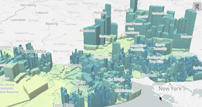
MADTIN has explored 3D Maps and create footprints to stakeholders with a better understanding of what is happening where, allowing for a faster and more engaged decision-making process. With Organization struggling to create and maintain 3D maps that can foster the adoption of 3D visualizations for a wide range of use cases such as urban planning, emergency management, and real estate.
More facts - MADTIN Technologies leverage 3D maps with data such as heights of the structures to get more realistic and bring out more facts in the following way-:
Greater context - We see our world in 3D, so when we transform a flat 2D map of our cities or mountains into a 3D map, it immediately creates greater connection and a sense of perspective.
Added dimension - 3D maps don’t just have to be based on ‘relative’ heights, you can use the 3D effect to add a new dimension to your visualizations, such as population per town, to communicate key insights at a glance.
Improved presentation - Sometimes it is very difficult getting people engaged and connected to their data. 3D maps go a long way to improve the report design and presentation of the report which gets people interested in the data.
MADTIN always believe in exploring different ideas and going beyond the common knowledge to solve business needs and provide exceptional quality of services.